Due to a ransomware attack, the wiki was reverted to a July 2022 version. . We apologize for the lack of a more recent valid backup.
...
In its default state (where no "regions" or "layouts" are defined), it should look and behave similarly to (and eventually , the same as) the "classic" Topology view.
...
- <region-id> is a unique identifier for the region
- <region-name> is a human readable name for the region
- <region-type> is one of the values defined in the Region.Type enumeration:
- CONTINENT, COUNTRY, METRO, CAMPUS, BUILDING, DATA_CENTER, FLOOR, ROOM, RACK, LOGICAL_GROUP
- <lat/Y>, <long/X> are the latitude / longitude (for geo layouts) or Y-coord / X-coord (for grid layouts) to be assigned to the region when it is displayed as a node in its parent layout.
- <locType> is either geo (for geographical (map) layoutto indicate coords are lat/long) or grid (for logical grid layoutto indicate coords are Y/X).
- <region-master> is a list of sets of node-IDs for mastership of the devices (see RegionAddCommand for more details).
...
| Code Block |
|---|
region-add-devices rUK \
    of:0000000000000001 \
    of:0000000000000002 \
of:0000000000000003 |
regions
The regions currently configured regions in the system can be listed with the regions command:
...
| Code Block |
|---|
onos> regions id=rDE, name=Germany, type=COUNTRY master=[localhost] of:0000000000000013 of:0000000000000014 of:0000000000000015 of:0000000000000016 of:0000000000000017 id=rES, name=Spain, type=COUNTRY master=[localhost] of:0000000000000018 ... |
...
(Another region command we'll look at is region-add-peer-loc, but we'll defer that until we have covered layouts).
Note that regions do not have any notion of hierarchy; they are simply "collections of devices". The hierarchy is expressed using Layouts.
...
A Layout is a "UI construct" that has an associated region "backing" it. Layouts define some other layout as its parent (except for the "root" layout, of course)) declare their parent layout, thereby allowing defining a hierarchy of layouts to be constructed.
This could be pictured as shown hereThe following diagram illustrates an example:

Note that the "root" (default) layout does not have a backing region. Any devices (and their attached hosts) that have not been assigned to a region will appear in the topology view at this top level.
...
| Code Block |
|---|
layout-add root @europe . . 4.66 -2562.93 -412.56 layout-add lUK @europe rUK root 11.63 -6652.54 -938.04 layout-add lIT @europe rIT root 7.15 -4818.73 -1330.36 layout-add lFR @europe rFR root 8.98 -5378.99 -1334.77 layout-add lMilan +segmentRouting rMilan lIT 0.86 68.58 54.71 |
Notes on <bg-ref>:
The <bg-ref> parameter should take the form:
"." : to define no background,"@{map-id}" : to define a geo background, or"+{sprite-id}" : to define a grid layout background
Map identifiers can be listed by using the ui-geo-map-list command in the onos CLI:
| Code Block |
|---|
onos> ui-geo-map-list
UiTopoMap{id=australia, desc=Australia}
UiTopoMap{id=americas, desc=North, Central and South America}
UiTopoMap{id=n_america, desc=North America}
UiTopoMap{id=s_america, desc=South America}
... |
Additional maps can be registered from an application's server-side UiExtension implementation.
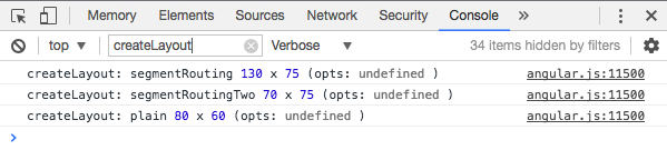
Sprite identifiers can be listed by opening the web console, making sure verbose option is selected, and filtering for the string "createLayout":
Additional sprite layouts can be registered from an application's topology overlay JavaScript code.
(need link to tutorial on building a custom topo2 overlay)
Notes on <scale>Note that currently the <scale>, <offset-x>, <offset-y> values can be determined by trial and error. See the section on Useful Techniques below for more detailsvalues:
Currently, getting these values right is a manual process:
- start by setting them to
1.0 0.0 0.0 - enable debugging of UiWebSocket to see message transmissions between client and server
- onos> log:set DEBUG org.onosproject.ui.impl.UiWebSocket
- in the UI, pan and zoom the map to the desired location
- in the log, identify the last UiWebSocket RX message for "updateMeta2"
2017-05-26 17:07:15,750 | DEBUG | tp1445302012-173 | UiWebSocket| 158 - org.onosproject.onos-gui - 1.11.0.SNAPSHOT | RX message:{"event":"updateMeta2","payload":{"id":"layoutZoom","memento":{"scale":4.66,"offsetX":-2560.646888427734,"offsetY":-409.13537841796875}}}
- use the values listed in the "memento" for your scripted command (you should be safe rounding to 4 decimal places)
- start by setting them to
One further note:
If the user zooms and pans a layout, the UI will remember how they left it.
However, by pressing the 'R' key, the map/grid will reset to the values configured in the layout-add command.